
Understanding Subdivision Surveys in Clyde North
What is a Subdivision Survey?
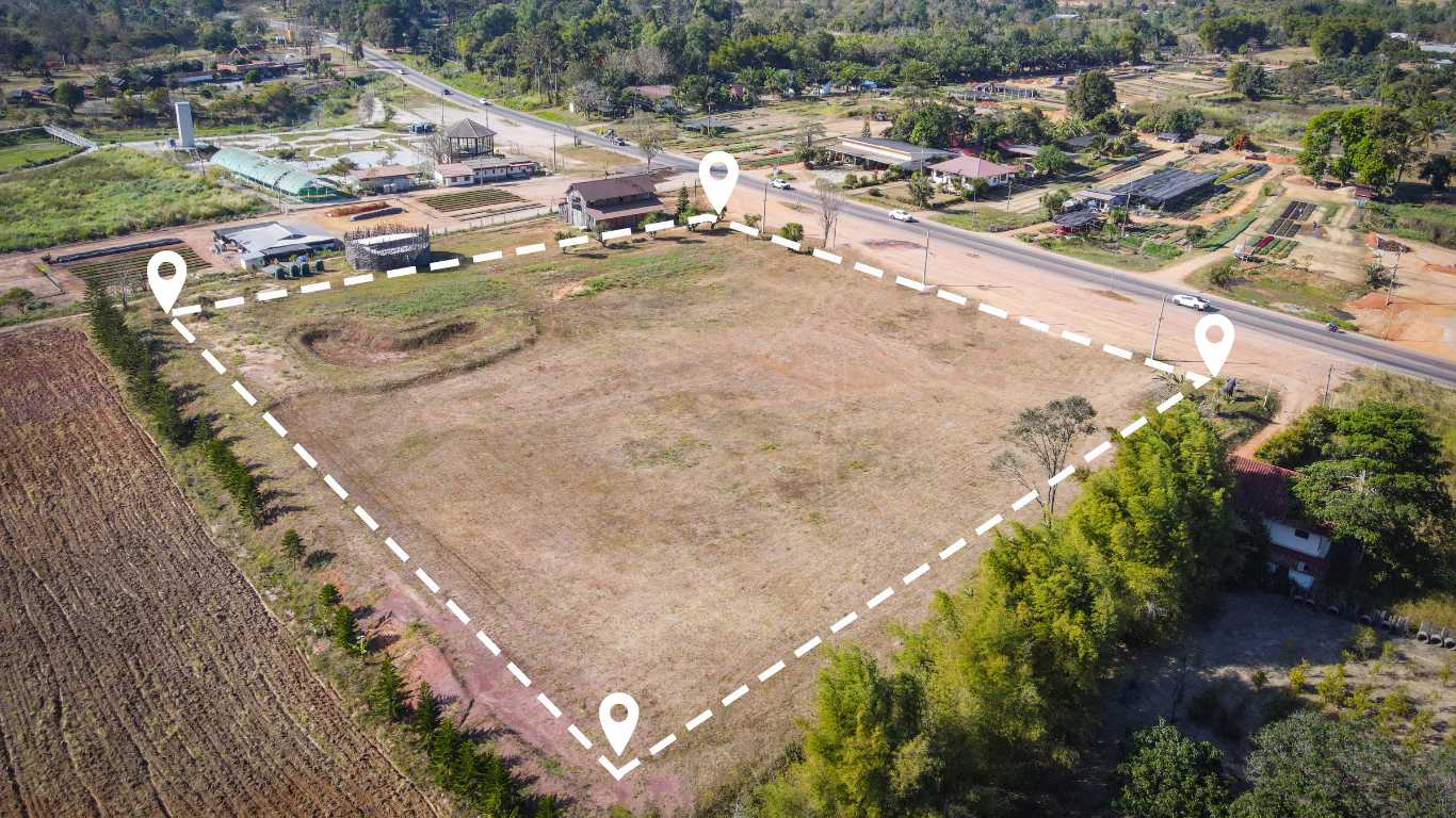
A subdivision survey is a meticulous procedure that delineates land into smaller parcels, ensuring these divisions meet local zoning and planning regulations. The process is essential for achieving clarity in property boundaries and facilitating developments. Key steps involved in a subdivision survey include:
- Initial consultation with landowners to understand their objectives.
- Conducting a comprehensive site analysis to assess the land.
- Mapping existing land features, including topography, vegetation, and utilities.
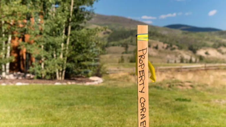
- Determining property boundaries through legal documentation.
- Preparing a subdivision plan that complies with local regulations.
- Submitting the plan for approval to relevant authorities.
- Finalising the survey and preparing official documentation for land titles.
Each of these steps requires a careful balance of technical knowledge and compliance with local laws. The surveyor must be adept in various surveying techniques, including the use of modern technology, to ensure the accuracy and reliability of the subdivision plan. Ultimately, a well-executed subdivision survey provides clarity and prevents potential disputes over land ownership.

Importance of Accurate Surveys
Accurate surveys are fundamental to the subdivision process, as they safeguard both legal standing and practical applications of land use. The precision in establishing new property boundaries is critical, as inaccuracies can have far-reaching implications. Potential issues stemming from inaccurate surveys include:
- Legal disputes between landowners over boundary lines.
- Increased costs due to delays in obtaining approvals.
- Challenges in financing or insuring properties.
- Non-compliance with local zoning and planning regulations.
When surveys are inaccurate, landowners risk significant financial loss and complications with future developments. Moreover, such inaccuracies can lead to disputes among neighbours, further complicating the subdivision process. A thorough understanding of the implications of survey accuracy reinforces the necessity for skilled surveyors and rigorous surveying practices.
Surveyor’s Role in Subdivision
Surveyors are integral to the subdivision process, providing expertise from the initial planning phases to the completion of the project. Their role encompasses not just technical measurement, but also an understanding of legal frameworks and local regulations. Surveyors ensure that all data collected is not only precise but also compliant with local laws, which is essential for both the subdivision’s feasibility and its legal validity.
In the planning stage, surveyors evaluate the land, identifying any potential challenges or restrictions. They then develop a subdivision plan that outlines how the land will be divided, ensuring that it meets the necessary regulations. Once the plan is submitted, surveyors may also assist in presenting the proposal to local authorities, advocating for the project while addressing any concerns that may arise. Their ongoing involvement is crucial for ensuring that the project remains on track and compliant throughout its development.
Expert Insights on Subdivision Surveys in Clyde North
What Qualifications Should a Surveyor Have?
Surveyors must possess specific educational and professional qualifications to conduct subdivision surveys effectively. Typically, they hold a degree in surveying or a related field, along with registration with the relevant professional body, such as the Surveyors Registration Board in Victoria. Additionally, ongoing professional development is vital for staying updated on industry standards and technological advancements.
Real-world examples illustrate the impact of surveyor qualifications on project outcomes. For instance, a surveyor with extensive experience in subdivision projects may better navigate complex regulatory requirements, leading to smoother project execution. Conversely, a less experienced surveyor may overlook critical details, resulting in costly delays or legal complications. An adept surveyor not only possesses technical skills but also demonstrates strong communication and project management abilities, which are essential for successful collaboration with clients and regulatory bodies.
How Do Surveyors Use Technology?
Modern surveyors leverage advanced technologies, such as GPS and drones, significantly enhancing the accuracy and efficiency of their surveys. These technologies allow for rapid data collection and precise mapping, which are crucial in the subdivision process. The integration of technology in surveying practices involves several actionable steps.
First, surveyors can incorporate GPS technology to obtain accurate geographical data, which is essential for determining property boundaries. This technology aids in achieving precise measurements that are vital for compliance with planning regulations. Additionally, drones enable surveyors to capture high-resolution aerial imagery, providing a comprehensive overview of the land’s features and contours.
Training staff in the use of these technologies is also essential. By ensuring that surveyors are proficient in modern tools, firms can enhance their capabilities and offer superior services to clients. Adopting these technologies not only streamlines the surveying process but also reduces potential errors, ultimately leading to more successful subdivision outcomes.
Case Studies of Successful Subdivisions
Examining case studies of successful subdivisions provides invaluable insights into the practical application of subdivision surveys. One notable example involves a residential development in Clyde North, where thorough planning and execution were paramount to its success. The project began with an extensive feasibility study, wherein surveyors assessed the land for suitability, taking into account factors such as accessibility, proximity to amenities, and compliance with local regulations.
The survey team collaborated closely with town planners, ensuring that the subdivision met all zoning requirements and community standards. As a result, the project not only gained approval swiftly but also attracted significant interest from potential buyers due to its strategic location and thoughtful design. The lessons learned from this case highlight the importance of early engagement with regulatory bodies and the necessity for meticulous planning.
Another case study illustrates the benefits of incorporating community feedback into the subdivision process. By hosting consultation sessions, surveyors and developers were able to address local concerns proactively, leading to a design that enhanced community amenities and open spaces. This approach not only facilitated smoother approval processes but also fostered a sense of community ownership over the development.
How to Navigate Regulatory Requirements for Subdivision Surveys
Navigating the regulatory landscape for subdivision surveys is crucial for ensuring project success. Compliance with local regulations not only mitigates legal risks but also streamlines the approval process. Key steps in this journey include:
- Researching local zoning laws and planning frameworks.
- Engaging early with local planning authorities to clarify requirements.
- Preparing and submitting a comprehensive subdivision plan.
- Addressing any feedback or concerns from regulatory bodies promptly.
Understanding the nuances of local regulations can be complex. Engaging a surveyor who is well-versed in these requirements can provide significant advantages, as they can offer insights into potential challenges and recommended strategies. Additionally, staying informed about changes in legislation or policy can help landowners anticipate shifts that may affect their projects, ensuring that compliance is maintained throughout the subdivision process.
Legal Aspects of Subdivision Surveys in Clyde North
What Are the Legal Requirements for Subdivision?
Subdivision surveys must adhere to various legal requirements to ensure legitimacy and compliance with local laws. Key legal documents required for subdivision include:
- Land title deeds that establish ownership.
- Planning permits obtained from local councils.
- Zoning certificates to confirm compliance with land use regulations.
- Environmental assessments, if applicable.
Navigating these legal requirements is essential for landowners looking to subdivide, as failure to comply can result in significant delays or even project rejection. Understanding the local regulatory framework is paramount; thus, engaging with a qualified surveyor can provide clarity on the necessary paperwork and legal obligations. It is advisable to consult with legal experts when dealing with complex land title issues to ensure that all aspects are managed properly.
How Does the Planning Process Work?
The planning process for subdivision involves multiple stages, each requiring careful attention to ensure compliance and efficiency. Initially, landowners must prepare a comprehensive application that outlines their proposed subdivision. This application typically includes detailed plans and documentation, which are then submitted to the local council for assessment.
Upon submission, the council reviews the application against local planning policies and regulations. This stage may involve community consultation, where feedback from local residents is sought. Addressing any concerns raised during this phase is crucial, as it can significantly impact the approval process. Once the application meets all requirements, the council will issue a planning permit, allowing the subdivision to proceed.
Following the approval of the planning permit, surveyors can then prepare the final subdivision plan, which must be lodged for registration with the land titles office. This plan delineates the new property boundaries and is essential for the legal recognition of the subdivided lots. Each stage of the planning process is interconnected, highlighting the importance of thorough preparation and compliance.
Dealing with Land Title Issues
Land title issues can present significant challenges during subdivision projects, potentially leading to delays and disputes. Addressing these issues early in the process is essential to avoid complications further down the line. One of the primary strategies for managing land title issues is conducting thorough title searches. This involves investigating the history of the land to identify any encumbrances, easements, or covenants that may affect the subdivision.
Engaging with legal experts familiar with land law can provide valuable insights into potential title disputes. They can assist in navigating complex title issues and proposing solutions that align with legal requirements. Additionally, ensuring clear communication between all stakeholders, including landowners, surveyors, and legal counsel, can help mitigate misunderstandings and streamline the process.
Planning for potential title issues is also advisable. For example, creating contingency plans for negotiating disputes or addressing encumbrances can save time and resources. Proactive management of land title issues not only reduces legal risks but also contributes to a smoother subdivision process.
What Are the Benefits of Subdivision Surveys in Clyde North?
Increased Property Value
Subdivision can substantially increase the value of a property by creating additional lots for sale or development. This financial boon is particularly advantageous for landowners looking to maximise their investment. When land is subdivided into smaller parcels, it becomes more appealing to a wider range of buyers, including developers and individual homeowners seeking affordable housing options.
Investors often recognise the potential for greater returns on subdivided properties, making them more attractive in the real estate market. The creation of additional lots can lead to increased demand, driving up property values. By carefully planning subdivisions that consider market trends and community needs, landowners can significantly enhance their financial outcomes.
Moreover, subdivided land can facilitate a variety of development opportunities, such as residential housing, commercial properties, or community amenities. This flexibility can further contribute to the overall value of the property, as well-planned subdivisions are viewed favourably by local councils and communities alike.
What Opportunities Does Subdivision Create?
Subdivision opens up numerous opportunities for landowners and developers alike, fostering growth and community development. One of the most significant opportunities is the potential for new housing developments. As population growth continues to surge in Clyde North, the demand for housing options becomes increasingly pressing. Subdivision allows landowners to contribute to meeting this demand by creating new residential lots.
Beyond residential opportunities, subdivision can also lead to commercial projects that enhance local economic activity. By dividing larger parcels of land, developers can create mixed-use developments that integrate residential, commercial, and recreational spaces, contributing to vibrant communities. These developments can lead to improved infrastructure and amenities, ultimately benefiting local residents.
Furthermore, subdivision contributes to the enhancement of community features, such as parks and public spaces. Thoughtfully planned subdivisions can incorporate green spaces, walking paths, and community facilities, promoting a sense of belonging among residents. This emphasis on community development not only increases property value but also fosters a more connected and thriving local environment.
Enhancing Land Use Efficiency
Subdivision surveys play a crucial role in enhancing land use efficiency, particularly in response to growing populations and changing land use demands. By dividing larger parcels into smaller, more manageable lots, landowners can make the most of their properties while meeting community needs. This process allows for better allocation of land resources, ensuring that developments align with both environmental sustainability and urban planning goals.
Efficient land use is critical in urban areas like Clyde North, where demand for housing and commercial space is ever-increasing. Subdivision facilitates the creation of denser developments, optimising land usage while preserving green spaces and natural resources. This approach not only addresses housing shortages but also aims to reduce urban sprawl, promoting smarter growth patterns.
Moreover, subdividing land allows for more specialised developments. Smaller parcels can cater to niche markets, such as affordable housing or eco-friendly homes, aligning with evolving community priorities. As land use patterns continue to shift, subdivision surveys will remain a pivotal tool in optimising land resources and enhancing the quality of life for residents.
How to Prepare for a Subdivision Survey in Clyde North?
What Documentation is Required?
Before embarking on a subdivision survey, landowners must gather essential documentation to facilitate a smooth process. Key documents required include:
- Current property titles that establish ownership.
- Zoning information detailing applicable land use regulations.
- Existing survey data, if available, to inform the new survey.
- Any previous planning permits or relevant correspondence with local authorities.
Collecting these documents beforehand ensures that landowners are well-prepared for the survey process. This preparation not only expedites the survey but also allows surveyors to focus on the technical aspects of the subdivision rather than wasting time on paperwork. Having accurate and up-to-date documentation is vital for demonstrating compliance with local regulations and facilitating a successful outcome.
Additionally, landowners should consider engaging with surveyors early in the process to discuss the specific documentation required for their unique situation. A surveyor’s expertise can help identify any additional information that may be needed and guide landowners through the documentation process, ensuring all necessary elements are in place.
Engaging with Local Authorities
Engaging with local councils and planning authorities is a critical step in navigating the regulatory aspects of subdivision. This engagement ensures that landowners understand and comply with local zoning laws and obtain the necessary permits for their projects. The process begins with conducting research on local planning requirements, which can vary significantly between councils.
Landowners should proactively reach out to their local council to discuss their subdivision intentions. This communication can provide valuable insights into any potential issues that may arise, as well as the specific documentation required for submission. By maintaining open lines of communication, landowners can foster positive relationships with local authorities, who may provide guidance throughout the application process.
Attending community consultation meetings hosted by the council is also advisable. These meetings offer opportunities to gather feedback from local residents and stakeholders, which can be invaluable in refining the subdivision proposal. Addressing community concerns early on not only enhances the likelihood of approval but also contributes to the development of a subdivision that aligns with local needs and aspirations.
Budgeting for the Subdivision Process
Budgeting for the subdivision process is essential for managing various costs effectively and avoiding financial surprises. Subdivision surveys involve a range of expenses, including surveyor fees, legal costs, and application fees for permits. Proper budgeting requires careful planning and consideration of all potential expenses associated with the project.
Begin by obtaining detailed quotes from surveyors, as their fees can vary depending on the complexity of the project and the services provided. Additionally, landowners should factor in costs related to legal counsel, especially if dealing with complex title issues or land use regulations. Setting aside a contingency fund for unexpected expenses can also be beneficial, as this ensures that landowners are prepared for any unforeseen challenges that may arise during the subdivision process.
Another consideration is the timeline for completing the subdivision. Delays in approvals or unforeseen complications can increase costs, so understanding the project timeline and potential risks is essential for effective budgeting. Regularly reviewing the budget throughout the project can help ensure that landowners remain on track financially and are equipped to address any issues that may emerge.
Assessing the Land’s Suitability
Before proceeding with a subdivision, it is crucial to assess the land for suitability, considering various factors that may impact the feasibility of the project. Key considerations include topography, soil type, and environmental impact. Conducting a site analysis helps landowners understand the unique characteristics of their property, which can inform the subdivision design.
Topography plays a significant role in determining how land can be divided and developed. Landowners should evaluate elevation changes, slopes, and any natural features that may influence construction or accessibility. Soil type is equally important, as certain soil conditions may require special considerations for building foundations or drainage.
Environmental impact assessments are also vital in understanding how the subdivision may affect local ecosystems. Engaging with environmental consultants can help identify any potential issues and develop strategies to mitigate negative impacts. Assessing the land’s suitability not only ensures the feasibility of the subdivision but also contributes to responsible and sustainable development practices.
Choosing the Right Surveyor
Selecting an experienced surveyor familiar with local regulations is vital for a successful subdivision survey. The right surveyor brings a wealth of knowledge and expertise that can significantly influence the outcome of the project. When evaluating potential surveyors, landowners should consider several factors, including experience, qualifications, and familiarity with local regulations.
Researching surveyors in the area can provide insights into their track record and reputation. Recommendations from peers or real estate professionals can also be invaluable in identifying surveyors with a proven history of successful projects. Once potential surveyors have been identified, conducting interviews or consultations can help gauge their understanding of the subdivision process and their approach to client communication.
Additionally, landowners should inquire about the technology and tools the surveyor uses, as modern advancements can enhance the accuracy and efficiency of the survey. Ultimately, selecting the right surveyor involves thoroughly assessing qualifications and ensuring alignment with the specific needs of the subdivision project.
Trusted Strategies for Subdivision Surveys in Clyde North
What Are Best Practices for Subdivision?
Best practices in subdivision encompass a holistic approach that emphasises thorough planning, engagement with experienced surveyors, and compliance with all regulations. Adhering to these strategies not only facilitates successful outcomes but also enhances the overall quality of the development.
Begin with a comprehensive feasibility study to assess the site and its potential for subdivision. Engaging experienced surveyors at this stage is crucial, as their insights can inform the design and identify any regulatory challenges early on. Establishing clear communication channels between all stakeholders, including landowners, surveyors, and local authorities, fosters collaboration and minimises misunderstandings.
Ensuring compliance with zoning regulations and local planning policies is paramount. Conducting regular reviews of the project against regulatory requirements throughout the process can help identify potential issues before they escalate. Additionally, incorporating community feedback into the subdivision design promotes positive relationships with local residents and enhances the project’s reception.
Finally, implementing effective project management strategies can help keep the subdivision on track. Setting realistic deadlines and regularly reviewing progress against the timeline ensures that all parties remain accountable and responsive to any challenges that arise.
How to Choose the Right Surveyor?
Selecting the right surveyor is critical for a successful subdivision project. Evaluating potential surveyors involves considering several key factors, including their experience, qualifications, and familiarity with local regulations. Start by researching surveyors in the Clyde North area, seeking out professionals with a solid reputation and a proven track record in subdivision projects.
Conducting interviews or consultations with prospective surveyors can provide insights into their approach and expertise. Ask about their experience with similar projects, as well as their familiarity with local zoning laws and planning requirements. A competent surveyor should be able to demonstrate a comprehensive understanding of the subdivision process and articulate how they plan to navigate any potential challenges.
Additionally, consider the technology and tools the surveyor employs, as modern advancements can greatly enhance the accuracy and efficiency of the survey. Requesting references from previous clients can also provide valuable insights into the surveyor’s work ethic and reliability. Ultimately, the right surveyor should align with the specific needs and objectives of the subdivision project, ensuring a successful outcome.
Managing Project Timelines
Effective management of project timelines is essential for keeping subdivision surveys on track. Setting realistic deadlines and regularly reviewing progress can mitigate potential delays and ensure that all stakeholders remain aligned. Begin by developing a detailed project timeline that outlines key milestones and deadlines for each phase of the subdivision process.
Regular communication with all parties involved is crucial for managing timelines effectively. Schedule progress meetings to discuss updates, address any concerns, and reassess deadlines as necessary. These meetings foster accountability and encourage collaboration among stakeholders, ensuring that everyone is working towards a common goal.
Incorporating buffer time into the project timeline is also advisable. This allows for flexibility in addressing unforeseen challenges or delays, minimising their impact on the overall project. Real-world examples highlight the benefits of proactive timeline management, with successful subdivision projects often reflecting meticulous planning and adaptive approaches that respond to challenges while maintaining momentum.
Future Trends in Subdivision Surveys in Clyde North
What Technological Advances Are on the Horizon?
Future technological advances in surveying promise to revolutionise the subdivision process further. Innovations such as sophisticated drones, artificial intelligence (AI)-driven data analysis, and enhanced GPS systems are on the horizon, poised to improve both accuracy and efficiency in subdivision surveys.
Drones are increasingly being utilised to capture high-resolution aerial imagery and perform topographical surveys. As drone technology continues to evolve, its capabilities will expand, allowing for more detailed data collection and analysis. AI-driven data analysis may also play a crucial role in interpreting survey data, enabling surveyors to identify patterns and insights that can inform decision-making processes.
Enhanced GPS systems are expected to provide even more precise location data, facilitating accurate boundary determinations and improving overall survey reliability. As these technologies become more integrated into surveying practices, surveyors will be better equipped to deliver high-quality services that align with evolving industry standards and client expectations.
Staying abreast of these technological advancements is crucial for surveyors and landowners alike. By embracing new tools and methodologies, they can enhance their capabilities and remain competitive in a rapidly changing market.
How Will Regulations Evolve?
Regulations governing subdivision surveys are likely to evolve in response to emerging challenges and opportunities, such as sustainability and smart city developments. As urbanisation continues to impact communities, local councils are likely to adapt their planning policies to address new environmental concerns, infrastructure needs, and population dynamics.
Regulatory frameworks may increasingly emphasise sustainable development practices, requiring subdivisions to incorporate green spaces, energy-efficient designs, and innovative stormwater management solutions. Additionally, as technology becomes more embedded in urban planning, regulations may evolve to facilitate smart city initiatives that leverage data and technology for improved community outcomes.
Staying informed about these regulatory changes is crucial for surveyors and developers involved in the subdivision process. Engaging with local planning authorities and participating in industry forums can provide insights into anticipated shifts in regulations, allowing stakeholders to proactively adapt their strategies and ensure compliance.
The Impact of Urban Growth on Subdivision
Urban growth will continue to have a profound influence on subdivision practices, particularly as demand for residential and commercial spaces escalates. As Clyde North experiences rapid population growth, the need for innovative approaches to land division and development becomes increasingly pressing.
Subdivisions must focus on creating well-planned communities that address the needs of a growing population while also considering environmental sustainability. This includes integrating mixed-use developments that provide housing, commercial opportunities, and community amenities, fostering vibrant and connected neighbourhoods.
Moreover, as urban growth intensifies, the trend towards higher-density developments is likely to gain momentum. Subdivisions may increasingly focus on maximising land use efficiency, creating smaller, well-designed lots that accommodate diverse housing options. This shift towards higher-density living can contribute to reducing urban sprawl and promoting more sustainable land use patterns.
As urban growth continues to shape the landscape of Clyde North, subdivision surveys will remain a critical tool for facilitating responsible development that meets the needs of the community while ensuring compliance with regulatory frameworks.
FAQs
What is a subdivision survey?
A subdivision survey is a detailed process that maps out land for division into smaller parcels, ensuring compliance with local regulations and accurate land measurements.
Why are accurate surveys important?
Accurate surveys are crucial for establishing correct property boundaries, avoiding legal disputes, and ensuring compliance with local zoning laws.
What qualifications should a surveyor have?
Surveyors should possess a degree in surveying, be registered with relevant professional bodies, and engage in ongoing professional development.
How do surveyors use technology?
Surveyors use advanced technologies like GPS and drones to enhance survey accuracy and efficiency, enabling quicker and more precise data collection.
What are the legal requirements for subdivision?
Legal requirements include obtaining planning permits, ensuring compliance with zoning laws, and preparing necessary documentation for land title registration.
How does the planning process work?
The planning process involves submitting an application to local authorities, obtaining community feedback, and finalising a subdivision plan for approval.
What opportunities does subdivision create?
Subdivision creates opportunities for new housing developments, commercial projects, and enhanced community amenities, contributing to local economic growth.
What documentation is required for a subdivision survey?
Required documentation includes property titles, zoning information, existing survey data, and previous planning permits or correspondence with authorities.
How can I choose the right surveyor?
Selecting the right surveyor involves assessing their experience, qualifications, and familiarity with local regulations, as well as checking references and previous work.
What are best practices for subdivision surveys?
Best practices include thorough planning, engaging experienced surveyors, ensuring compliance with regulations, and incorporating community feedback into the design.
Connect with us on Facebook!


Land Surveyor Services
Get A Free Quote
Contact us today for a free, no-obligation quote on your Surveying Needs