

Understanding Re-establishment Surveys
What is a Re-establishment Survey?
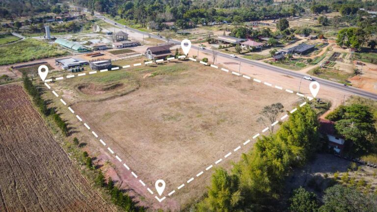
A re-establishment survey is a critical process in the realm of property management and development, focusing on redefining property boundaries based on historical data and contemporary surveying techniques. This survey is not merely an administrative task but a meticulous activity that ensures someone’s land ownership is clearly defined and legally defensible. By analysing old survey records, title documents, and leveraging modern technology, surveyors can accurately determine the original boundaries of a property.
In practical terms, a re-establishment survey begins by examining historical land records to establish a baseline of the property’s boundaries. This foundational work is paramount because it provides the surveyor with essential insights into previous surveys and any alterations made over time. The ultimate goal is to produce a precise boundary definition that can withstand legal scrutiny and lay a solid groundwork for future property dealings or developments.

Importance of Accurate Surveys
Accurate surveys are the bedrock of numerous property-related activities, impacting everything from property transactions to development plans. For buyers, sellers, and developers in Tarneit, an accurate survey ensures that all parties are clear about the property boundaries, thus mitigating the risk of disputes. Moreover, in a bustling region like Tarneit, where land development is prevalent, having precise boundary definitions can influence zoning, compliance with local regulations, and the overall feasibility of development projects.
Additionally, accurate boundary surveys play a pivotal role in resolving potential boundary disputes. When property lines are clearly defined, the likelihood of conflicts between neighbours diminishes significantly. This clarity not only fosters goodwill among property owners but also protects them against legal challenges. Consequently, investing in a proper re-establishment survey can save property owners considerable time, money, and stress in the long run.
Legal Requirements in Victoria
In Victoria, re-establishment surveys must comply with specific legal frameworks to ensure their validity. Primarily, this is governed by the Surveyors Act 2003 and the Surveying (Cadastral Surveys) Regulations 2005. These regulations outline the standards and practices that licensed surveyors must adhere to when conducting surveys. Understanding these legal requirements is crucial for property owners to ensure that the surveys conducted are enforceable in court and recognised by local authorities.
Furthermore, the legal requirements stipulate that all survey plans and reports must be adequately documented and submitted to the relevant authorities. This process not only ensures transparency but also safeguards the interests of all stakeholders involved. For property owners in Tarneit, being aware of these legal stipulations is imperative when undergoing a re-establishment survey, as non-compliance can lead to significant repercussions, including invalidated surveys and legal disputes.
Expert Insights on Re-establishment Survey in Tarneit
Include real-world examples of successful re-establishment surveys
Several successful re-establishment surveys in Tarneit have highlighted the importance of clear property boundaries in resolving complex boundary issues. For instance, a notable case involved two neighbouring properties disputing a shared boundary line due to discrepancies in historical records. The surveyor undertook a detailed analysis of both properties using a combination of old survey plans and modern GPS technology.
Through this meticulous process, the surveyor was able to establish an accurate boundary line that satisfied both property owners, preventing a lengthy and costly legal battle. The methods employed in this case included:
- Comparative analysis of historical survey records
- Utilisation of advanced GPS technology for precise measurements
- On-site verification and stakeholder interviews
- Collaboration with local authorities for compliance
The outcome not only resolved the dispute but also set a precedent for future surveys in the area, showcasing the necessity for clear boundaries in community development. Such real-world applications illustrate the significance of engaging qualified professionals to conduct thorough re-establishment surveys, ultimately fostering a harmonious neighbourhood environment.
What are the common challenges faced?
Re-establishment surveys are fraught with challenges that can complicate the boundary definition process. One prevalent issue is the existence of incomplete or inaccurate historical records which can lead to ambiguities in boundary definitions. For surveyors, this requires a careful examination of available data, often necessitating additional research and validation steps to ensure credible outcomes.
Physical obstructions, such as fences, trees, and changes in land use, can also impede the surveying process. These obstacles may obscure original boundary markers, making it difficult for surveyors to pinpoint exact lines. Furthermore, disputes between neighbours can complicate matters, as conflicting interpretations of boundaries can lead to tensions that hinder the survey process. Understanding these challenges is crucial for surveyors and property owners alike, as foresight and strategic planning can mitigate many of these issues before they escalate.
How can technology enhance survey accuracy?
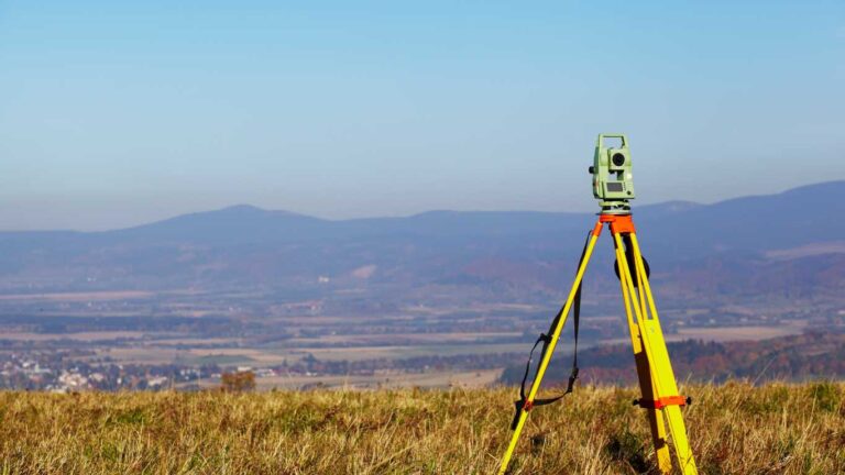
Modern surveying techniques increasingly leverage technology to enhance accuracy and efficiency in re-establishment surveys. Tools such as GPS and drones provide surveyors with precise measurements and comprehensive aerial imagery that can streamline the surveying process. These technologies allow for the quick gathering of data across large areas, significantly reducing the time required to perform traditional surveying tasks.
Geographic Information Systems (GIS) also play a vital role, enabling surveyors to create detailed maps that incorporate various data layers. This can include everything from historical land use to current topographical changes, allowing for a more holistic understanding of the land in question. By utilising these advanced technologies, surveyors can deliver highly accurate surveys, ensuring that property boundaries are clearly defined and legally defensible, which is particularly crucial in regions experiencing rapid growth, such as Tarneit.
How can community engagement improve survey outcomes?
Community engagement is a powerful tool that can significantly enhance the outcomes of re-establishment surveys in Tarneit. By involving local residents and stakeholders in the survey process, surveyors can gain valuable insights and contextual information that may not be readily available through historical records alone. This collaboration fosters goodwill and cooperation, leading to a more seamless survey process.
For instance, engaging with community members can reveal local knowledge about past land use, existing boundary markers, and any informal agreements between neighbours. These insights can inform the surveyor’s approach and help address potential disputes before they arise. Additionally, transparent communication about the survey process can build trust among stakeholders, encouraging them to support the survey’s findings and accept its results. This community-centric approach not only improves the accuracy of surveys but also enhances relationships among property owners, creating a more cohesive community in Tarneit.
What are the legal considerations for re-establishment surveys?
Conducting a re-establishment survey in Tarneit necessitates a thorough understanding of the legal landscape surrounding property boundaries. The primary legal frameworks to consider include property laws, notably the Surveyors Act 2003 and the Surveying (Cadastral Surveys) Regulations 2005, which stipulate the standards for surveying practices and documentation requirements.
It is essential for surveyors to maintain compliance with these regulations to ensure that their surveys are legally valid. This includes providing proper documentation of findings, adhering to industry standards, and ensuring that any boundary definitions are backed by solid evidence. Property owners must also be aware of their rights and obligations concerning land use and ownership, as any discrepancies or failures to comply with legal requirements can result in disputes or invalidation of the survey.
Additionally, it is advisable for surveyors and property owners to consult legal professionals when navigating complex boundary issues, particularly in cases where disputes may arise. This proactive approach can safeguard against legal challenges and ensure that all parties are well-informed about their rights and responsibilities.
Process of Conducting a Re-establishment Survey
Initial Research and Data Collection
The first step in conducting a re-establishment survey involves thorough initial research and data collection. This critical phase lays the groundwork for the entire survey process, as it seeks to gather all available historical data regarding the property in question. Surveyors typically begin by examining old survey plans, title documents, and aerial photographs to understand original boundaries and any modifications that have occurred over time.
This research phase may also involve consulting with local councils and land registries to access archived records that can provide insights into previous surveys. Understanding the historical context of the property is essential, as it helps to identify any potential issues that could emerge during the surveying process. Once this data is collected, the surveyor can move on to the next phase, armed with a comprehensive understanding of the property’s boundaries and any complexities that may need to be addressed.
Field Work and Boundary Marking
Fieldwork is a pivotal aspect of the re-establishment survey process, involving precise physical measurements and boundary marking. During this stage, surveyors utilise a range of advanced survey equipment, such as total stations and GPS systems, to ensure the highest level of accuracy. The fieldwork task typically includes locating existing boundary markers, measuring distances, and establishing new markers as required.
As the surveyor works on-site, they must pay close attention to the historical data collected earlier, ensuring that findings align with previous surveys. This requires a keen eye for detail and a thorough understanding of surveying principles. Additionally, engaging with property owners or neighbours during this phase can provide valuable verification of boundary markers and assist in clarifying any uncertainties. The outcome of this fieldwork is a clear and accurate depiction of the property boundaries, which will later form the basis for official documentation.
What documentation is required post-survey?
After completing the re-establishment survey, several essential documents must be prepared to formalise the findings and ensure compliance with legal requirements. Firstly, a new survey plan must be drawn up, depicting the re-established boundaries and any new markers placed during the survey. This plan serves as a visual representation of the property boundaries and is a crucial component of the documentation process.
In addition to the survey plan, a detailed report outlining the surveyor’s findings must be compiled. This report should include an explanation of the methodologies used, any challenges encountered during the survey, and the rationale behind the re-established boundaries. Furthermore, any necessary legal documentation, such as applications for updating property records with local authorities, must also be prepared.
Essential documents typically include:
- New survey plan detailing the re-established boundaries
- Surveyor’s report outlining methodologies and findings
- Legal applications for property record updates
- Evidence of historical boundary data used
This documentation is not only a requirement for legal compliance but serves as a reference for property owners and future transactions.
Analysis and Interpretation of Survey Data
Once fieldwork is complete and documentation is created, the next step involves the analysis and interpretation of the survey data collected. This phase is crucial for validating the accuracy of the boundaries defined during the survey. Surveyors meticulously analyse the data to confirm that the newly established boundaries align with historical records and comply with current legal standards.
This analysis often involves comparing various data sources, including GPS readings, historical survey plans, and information gathered from stakeholders during the survey. If discrepancies arise, further investigation may be necessary to reconcile differences and ensure that the final boundary definition is both accurate and defensible. The ultimate goal of this stage is to create a cohesive narrative that accurately represents the property’s boundaries and protects the interests of the property owner.
Trusted Strategies for Re-establishment Survey in Tarneit
Provide actionable steps for property owners
For property owners in Tarneit looking to initiate a re-establishment survey, a structured approach is essential to ensure a smooth process. Here’s a step-by-step guide that can assist in navigating through this important undertaking:
1. Research Local Surveyors: Start by researching qualified and experienced surveyors in Tarneit. Look for those who have a solid reputation and are familiar with local regulations.
2. Gather Historical Data: Before the survey, compile any available historical documents, including old survey plans, titles, and correspondence with neighbours that might aid the surveyor.
3. Communicate with Neighbours: Reach out to neighbouring property owners to discuss your plans. Their insights may provide valuable context and help prevent disputes during the surveying process.
4. Set Clear Expectations: When hiring a surveyor, clearly communicate your needs and expectations for the survey. Discuss timelines, costs, and the methodology they will employ.
5. Review Findings: Once the survey is complete, carefully review the results with your surveyor. Ensure you understand the implications of the findings for your property.
By following these steps, property owners can effectively manage the re-establishment survey process, ensuring that boundaries are accurately defined and legally compliant.
How to choose the right surveyor?
Choosing the right surveyor for a re-establishment survey is critical to achieving accurate results. Property owners should look for several key attributes when selecting a surveyor to ensure they are qualified and capable. Firstly, licensing is paramount; ensure that the surveyor holds a valid licence to operate in Victoria, as this indicates they meet the requisite professional standards.
Experience in the local area is also vital. Surveyors who have conducted surveys in Tarneit will possess valuable insights into local regulations, historical land records, and common boundary issues. Additionally, communication skills are important; a good surveyor should be able to explain complex concepts clearly and provide ongoing guidance throughout the process.
Lastly, consider asking for references or examples of previous work to gauge their expertise and reliability. By taking the time to choose a suitable surveyor, property owners can significantly enhance the likelihood of a successful re-establishment survey.
Cost considerations and budget planning
Understanding the costs associated with re-establishment surveys is essential for property owners to effectively plan their budgets. The total cost of a re-establishment survey can vary significantly based on several factors, including the complexity of the property, the size of the land, and the specific methodologies employed by the surveyor.
Property owners should anticipate expenses related to the surveyor’s fees, which may be charged on an hourly basis or as a flat fee for the entire project. Additionally, costs for equipment usage, such as GPS technology or drones, should be factored in, as well as potential legal fees for any required documentation or updates to property records.
To avoid financial surprises, it is prudent to obtain detailed quotes from multiple surveyors and discuss all potential costs upfront. Planning for unexpected expenses, such as additional research or dispute resolution, will also contribute to effective budget management. By having a comprehensive understanding of the costs involved, property owners can approach their re-establishment survey with confidence.
Importance of accurate documentation and record-keeping
Accurate documentation and meticulous record-keeping are fundamental components of the re-establishment survey process. Property owners must maintain detailed records of every aspect of the survey, from initial communications with the surveyor to the final survey report. This documentation serves multiple purposes, including legal protection and future reference.
Having a well-documented record ensures that property owners can defend their boundaries should disputes arise in the future. It also facilitates easier communication with local authorities when updating property records or addressing any issues that may emerge later on. Furthermore, accurate documentation can help streamline future transactions or property developments, as potential buyers or developers will want to review the survey history.
To safeguard against loss or miscommunication, property owners should consider digitising their documentation and storing it securely. This approach not only preserves important records but also allows for quick access when needed. By prioritising accurate documentation and record-keeping, property owners can protect their investments and ensure clarity surrounding their property boundaries.
Benefits of Re-establishment Surveys in Tarneit
Ensuring Legal Compliance
One of the foremost benefits of conducting a re-establishment survey is the assurance of legal compliance. In Tarneit, where property development is on the rise, having precise and legally defensible boundaries can significantly reduce the risk of future disputes. A re-establishment survey ensures that property boundaries comply with existing laws and regulations, which is vital for protecting ownership rights.
By ensuring compliance with the Surveyors Act 2003 and related regulations, property owners can avoid potential legal challenges that may arise from unclear or disputed boundaries. This proactive approach not only instills confidence in property owners but also enhances their standing in any future negotiations or transactions involving their land.
Facilitating Property Transactions
Accurate surveys play a pivotal role in facilitating smooth property transactions, particularly in a rapidly developing area like Tarneit. When property boundaries are well-defined and undisputed, the transaction process becomes significantly more straightforward for buyers and sellers alike. Clear boundaries reduce the risk of misunderstandings and disputes that could delay or derail property sales.
Moreover, having an accurate re-establishment survey can enhance a property’s marketability. Potential buyers are often more inclined to invest in properties with clearly defined boundaries, as this provides assurance regarding their investment. Consequently, properties that have undergone proper re-establishment surveys can command higher prices in the marketplace, benefiting sellers while fostering a more transparent real estate environment.
Enhancing Property Value
The value of a property is intrinsically linked to the clarity of its boundaries. Properties with well-defined and legally sound boundaries are not only more attractive to buyers but also tend to appreciate in value over time. In Tarneit, where property development and urbanisation are on the rise, having a re-establishment survey conducted can significantly enhance the resale value of a property.
Moreover, clear boundaries deter encroachments and disputes with neighbouring properties, further solidifying the property’s value. For property owners, investing in a re-establishment survey is a strategic decision that can lead to increased property value and long-term financial benefits. By ensuring that boundaries are accurately defined and legally compliant, owners position themselves favourably in the competitive real estate market.
Case Studies and Examples from Tarneit
Recent Re-establishment Surveys in Tarneit
Recent examples of re-establishment surveys in Tarneit have demonstrated the positive impact these surveys can have on both property owners and the community. One case involved a newly developed residential area where several homeowners were experiencing disputes over shared boundaries. A comprehensive re-establishment survey was commissioned to clarify property lines, and the surveyor’s findings revealed discrepancies in the original boundary definitions.
Through meticulous fieldwork and an analysis of historical data, the surveyor was able to resolve these disputes effectively. The outcome not only satisfied the property owners but also fostered a spirit of cooperation within the community. Such examples underscore the importance of timely and accurate surveys in maintaining harmony among neighbours and protecting property interests.
What can property owners learn from these examples?
Property owners in Tarneit can glean several valuable insights from recent re-establishment survey examples. Firstly, the importance of conducting surveys promptly cannot be overstated; delays can exacerbate disputes and complicate matters further. Engaging a qualified surveyor early in any potential boundary disagreement can help prevent conflicts from escalating.
Additionally, these case studies highlight the necessity for clear communication among neighbours. Proactively discussing boundary issues can lead to cooperative solutions and reduce tensions. Property owners are also reminded of the significance of documenting their property boundaries accurately. By doing so, they establish a strong foundation for resolving disputes should they arise in the future.
Lastly, the positive outcomes from these surveys emphasise the benefits of investing in professional surveying services. Engaging experienced surveyors who understand local regulations can vastly improve the chances of a successful re-establishment survey.
Future Trends in Surveying in Tarneit
As technology continues to evolve, the field of surveying is witnessing significant transformations that promise to enhance the accuracy and efficiency of re-establishment surveys in Tarneit. Emerging trends include the increased use of digital tools and data analytics. For instance, the adoption of 3D modelling and virtual reality can provide property owners and developers with a more comprehensive view of land use and boundaries.
Moreover, Artificial Intelligence (AI) is beginning to play a role in analysing historical land data, making it easier to identify discrepancies or patterns that could influence boundary definitions. These technological advancements are paving the way for more streamlined surveying processes, ultimately benefiting property owners by providing faster and more accurate results.
Additionally, there is a growing trend towards sustainability in surveying practices. Surveyors are increasingly considering environmental impacts and aiming to incorporate eco-friendly methods in their work. This shift not only aligns with broader societal goals but also resonates with property owners who prioritise sustainability in their investments.
Successful Case Studies of Boundary Dispute Resolution in Tarneit
Several successful case studies in Tarneit illustrate the effective resolution of boundary disputes through re-establishment surveys. One notable instance involved a longstanding disagreement between two homeowners regarding a fence that had been constructed several years prior, encroaching onto one of the properties.
By engaging a reputable surveyor, both parties were able to obtain a clear and accurate depiction of the property boundaries. The surveyor’s findings confirmed the rightful boundary, allowing the homeowner to make necessary adjustments without escalating the matter legally. This resolution not only preserved the relationship between neighbours but also reinforced the importance of proper surveys in preventing conflicts.
Another case involved a residential developer who faced pushback from neighbours over perceived boundary encroachments. A comprehensive re-establishment survey highlighted the property’s true boundaries, providing evidence that the developer was compliant with local regulations. This clarity led to a successful resolution, allowing the development to proceed as planned. These examples serve as powerful reminders of the critical role that re-establishment surveys play in maintaining harmonious relationships among property owners.
FAQs
What is a re-establishment survey?
A re-establishment survey involves redefining property boundaries using historical records and modern surveying techniques to ensure accuracy and legal compliance.
Why is an accurate survey important?
Accurate surveys provide clear property boundaries, crucial for property transactions, development planning, and resolving disputes, ensuring legal protection for owners.
What are the legal requirements for re-establishment surveys in Victoria?
In Victoria, re-establishment surveys must comply with the Surveyors Act 2003 and the Surveying (Cadastral Surveys) Regulations 2005 to be legally valid.
What challenges are faced during re-establishment surveys?
Common challenges include missing historical records, physical obstructions, and disputes between neighbours, which can complicate the surveying process.
How can technology improve survey accuracy?
Technologies like GPS, drones, and GIS mapping enhance survey accuracy and efficiency by providing precise measurements and comprehensive data analysis.
What should property owners do to initiate a re-establishment survey?
Property owners should research local surveyors, gather historical data, communicate with neighbours, and set clear expectations with the chosen surveyor.
How do I choose a qualified surveyor?
Look for licensed surveyors with local experience, strong communication skills, and positive references to ensure quality service.
What costs are associated with a re-establishment survey?
Costs can vary based on property complexity, including surveyor fees, equipment costs, and potential legal fees, making budget planning essential.
Why is documentation important in the survey process?
Accurate documentation protects property owners legally, facilitates future transactions, and provides a clear record of property boundaries.
What are the benefits of a re-establishment survey?
Benefits include legal compliance, smoother property transactions, and enhanced property value through clearly defined boundaries.
Connect with us on Facebook!

Land Surveyor Services
Get A Free Quote
Contact us today for a free, no-obligation quote on your Surveying Needs